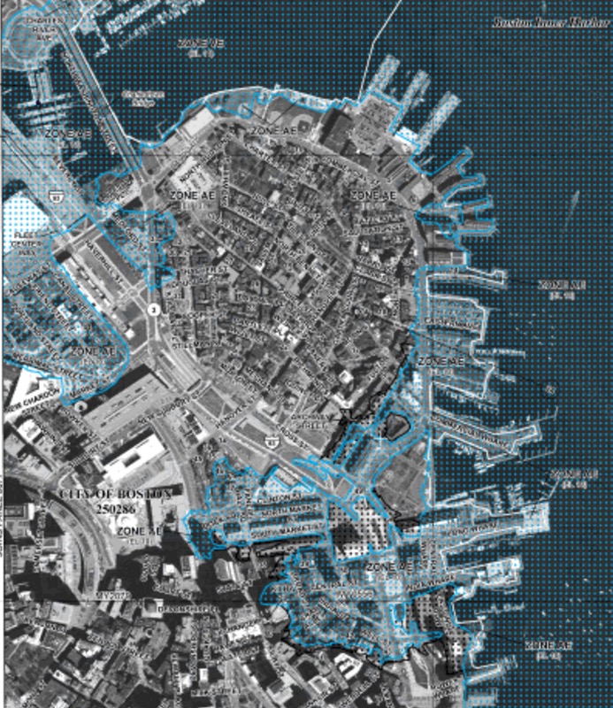
The Bomb Cyclone Storm of Jan. 4 left damage in its wet wake all along the local coast. You are invited to help others understand just where and how the North End experienced this storm. Our ability to educate ourselves more thoroughly about storm effects strengthens our sense of climate change readiness in the future. Read More…
Tag: Flooding
We Are Boston’s Waterfront Discusses Future Planning, What We Can Do Now
We Are Boston’s Waterfront hosted a community meeting with the Conservation Law Foundation on January 17, prompted by the recent storm flooding, to discuss the changes we are seeing to the waterfront and how we can plan for the future. Over 60 residents from the North End, Waterfront and surrounding neighborhoods attended, packing the Golden Goose Cafe Read More…
Waterfront Community Meeting – Planning for the Future
In response to last week’s storm and subsequent flooding, the Conservation Law Foundation is hosting a community meeting on Wednesday, January 17 from 6pm – 7pm at the Golden Goose Cafe to discuss the future of the waterfront. Read more below.
Storm Surge Brings Record Flooding to Waterfront Areas [Photos]
Record flooding was seen Thursday afternoon in the North End and the downtown Boston waterfront as a 3 foot storm surge came in with a 12 foot high tide on the harbor. Flood waters reached the Rose Kennedy Greenway, a first in Boston, and the highest levels since the Blizzard of ’78. The Aquarium T Read More…
Snow Emergency Continues into Friday as Cleanup Begins
https://twitter.com/b911nature/status/949082172182401024 As the storm moves out, the recovery efforts continue from the record flooding and 12+ inches of snow. Here are some updates. Trash will be picked up on Friday, but city officials are urging residents to put it clearly out by the curb. Schools are closed again with the Nazzaro Center open. The North Read More…
King Tide Brings Flooding to North End / Waterfront Sites
“King Tide,” the recurring high tides coincident with supermoons once again brought flooding on Sunday to waterfront paths behind the tennis courts, Langone Park and the Eliot School (under construction) on Commercial Street. Janine Coppola captures the sea level rise of Boston Harbor in the above photos. Long Wharf is another low point that regularly Read More…
New FEMA Flood Maps Become Effective March 2016
Video: Lauren Zingarelli from the Boston Environment Department discussed the new FEMA Flood Maps for the North End at the December 14, 2015 NEWNC meeting. Changes to the Flood Insurance Rate Maps for the City of Boston go into effect on March 16, 2016. Federal Emergency Management Agency (FEMA) has been revising flood maps to reflect Read More…
Boston Water & Sewer Work Floods Hanover Street
Extensive street flooding on Tuesday morning closed down Hanover Street along the Freedom Trail in Boston’s North End. The problem came about as part of the current sewer work in the neighborhood. Philip Frattaroli captures the scene in the tweet below saying, “Like a trip to Venice without the flight!” The North End: Like a trip to Venice without the flight! Read More…
Another Close Call as Blizzard Juno’s Storm Surge Peaks at Low Tide
If Blizzard Juno’s storm surge of 4.74 feet hit during high tide, it would have been a “100-year” flood event for Boston’s waterfront, reports Julie Wormser of The Boston Harbor Association. We were again very lucky as the surge hit during low-tide just after 11 a.m. on Tuesday. (See NOAA’s tide and current data.) Despite the miss, the morning Read More…
On Hurricane Sandy Anniversary, Mayor Walsh Kicks Off Climate Change Design Competition
The following release on climate change preparedness includes this week’s announcements by Mayor Martin Walsh and Boston City Hall. On the two-year anniversary of Hurricane Sandy, Mayor Martin J. Walsh announced the City of Boston will be convening a regional summit to better prepare Greater Boston for the impacts of climate change. The announcement also marked Read More…
The North End Waterfront and Sea Level Rise in Boston Harbor [Video Presentation]
[responsive_youtube http://www.youtube.com/watch?v=tVQ2tkdfN5g] The Boston Harbor Association gave an updated presentation to the North End community with their latest information and outlook regarding the rising tide in Boston Harbor and its potential flooding impacts on neighborhood residents, businesses and property owners. Most recently, a new preliminary flood zone map was issued by FEMA that includes much Read More…
High Tide During Blizzard of 2013 Floods North End Waterfront
The usual spots along the North End waterfront flooded at high tide from the storm surge associated with the February 8, 2013 blizzard. Significant water intrusions from Boston Harbor were seen at Long Wharf, Sargent’s Wharf and along the North End waterfront. Notably in this latest storm, the water surge reached inward past the Chart Read More…