Photos & Videos Transportation

Neighborhood Photo: Protecting the Aquarium MBTA Station

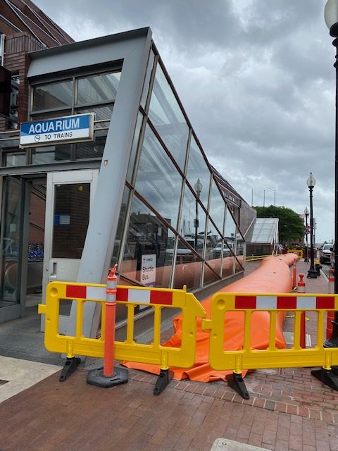
by Joanne Hayes Rines Employees from the MBTA surrounded the Aquarium T station with flood prevention tube and 5 T cars were parked on the street.  Other materials were on hand if the entrance was in danger of flooding.  “Neighborhood Photo” is a regular feature on NorthEndWaterfront.com. Send in your photos via email to info@northendwaterfront.com. Read More…

Photos & Videos

Neighborhood Photo: Lewis Wharf at High Tide

Monday’s high tide brought flooding to the North End’s Lewis Wharf. A “wicked high tide” is expected to bring more coastal flooding on Tuesday, when there will be a 12-foot high tide at 12:35 p.m. Similar conditions are predicted for Wednesday afternoon, when rainwater will add to the high tides. Photo submitted by Davida Carvin. Read More…

Community Featured Health & Environment

Reader Poll: Which Flood Resiliency Option Do You Support?

Boston’s Climate Ready Downtown and the North End Project team recently gave an update on their plans to protect the neighborhood from flooding due to rising sea levels. Two main options have been identified: 1. Raise the roadway and bike lanes by 5-7 feet. This has the advantage of being public property so it would be easier Read More…

Photos & Videos

Neighborhood Photo: Flooding at Lewis Wharf

Winter storm Harper came roaring through the Northeast this past weekend and, although it didn’t bring as high of snow totals as some forecasts were predicting (The Boston Globe marks Boston with only 4.9 inches), it still brought snow, sleet and rain to the city. The stormy weather, combined with two Boston Harbor high tides Read More…

Featured Health & Environment Real Estate

Elevating Sargent’s Wharf, Columbus, Langone Parks and Long Wharf in “Resilient Boston Harbor” Plan

Mayor Marty Walsh announced a broad plan to shore up several waterfront parcels from flooding, including in the North End and Downtown, as part his “Resilient Boston Harbor” vision. The City Hall strategy is a step forward in protecting the city from rising sea levels, especially during major storms and flooding events. In the North Read More…

Health & Environment Photos & Videos

Neighborhood Photo: Flooding at Puopolo Park

The grass vs. turf debate continues for Puopolo Park. John Romano points out that, when it rains, second base floods and the neighborhood baseball teams cannot play for three to five days. This has happened for many years. A turf field would eliminate the need to wait several days for the field to dry out. “Neighborhood Read More…

Featured Government Health & Environment Meetings

Hearing on Flooding Brings Together City Groups to Discuss Strategies & Solutions

On Monday, March 26th, Boston City Councilor At-Large and Chair of the Committee on Planning, Development & Transportation Michelle Wu held a hearing on flooding in Boston, focusing on strategies and solutions to combat more frequent and more intense flooding across the city due to climate change and sea level rise. Wu called for the Read More…

Government

Public Hearing To Discuss City Flooding March 26

A council hearing to discuss flooding in the City of Boston will take place on Monday, March 26th at 11am at City Hall. Members of the public are invited to attend and present information. You must arrive early and bring 15 copies of any written documentation. You can also send in written comments before the Read More…

Community Featured

Climate Change Rally Follows Flooding at Aquarium MBTA Station

Representatives from Boston Climate Action Network and We Are Boston’s Waterfront held a rally on Sunday afternoon outside the Aquarium MBTA station. The groups are seeking a moratorium on waterfront development, implementation of Community Choice Energy (CCE) and immediate action to protect against the flooding caused by sea level rise. Standing near the site of  the historic flooding Read More…

Photos & Videos

Saturday’s High Tide – Flooding Continues [Photos]

The third and final high tide of Nor’Easter Riley hit Boston Saturday afternoon around 12:05pm, bringing strong wind gusts and additional flooding to the North End Waterfront. See photos below. More photos from Langone Park, the HarborWalk and under the North Washington Bridge: “Neighborhood Photo” is a regular feature on NorthEndWaterfront.com. Submit your interesting photos using Read More…

Featured Health & Environment

Storm Surge From Nor’Easter Riley Floods Boston’s Waterfront at High Tide [Photos]

High tide hit around 11:15 a.m. Friday morning with a near record storm surge from Nor’Eater Rlley causing dramatic flooding on Boston’s waterfront. It was the second massive storm in just as many months after the January 4th snowstorm. Shown here are photos from the flooding impact along the North End waterfront toward Long Wharf and Atlantic Read More…

Featured Health & Environment

Coastal Storm Could Bring Record Flooding to Boston’s Waterfront

Friday’s Nor’easter will be a major coastal storm with flooding forecasted to be as bad, if not worse higher than during the January 4th snowstorm. With a 3 to 4 foot storm surge, the high tides could reach over 15 feet. Further, this storm will last over at least three high tide periods into Saturday. The Read More…