The Boston Planning and Development Agency (BPDA) Board of Directors recently approved adoption of the Coastal Flood Resilience Design Guidelines at their September Board Meeting.
The Guidelines, which build on Mayor Marty Walsh’s Climate Ready Boston (CRB) initiative, are intended to serve as a reference for residents, business owners and developers. The goal of the Design Guidelines is to raise awareness of future coastal flood risk, offer strategies to reduce damage and disruption, and provide consistent standards for review of projects that fall within the proposed Zoning Overlay District (which is currently under internal review). This new zoning district would provide the City with the authority to better enforce the resilient actions that are proposed in the Guidelines.

Because resilient enhancements could potentially increase property values, the Guidelines also recommends that resources be available to prevent negative impacts on affordability for vulnerable groups such as renters and students. As CRB and other city studies show, investments in flood hazard mitigation and other resilience measures can be very cost-effective; the National Institution of Building Sciences estimated that every $1 invested in mitigation prevents $6 in damage.
Included in the Guidelines, the resilience toolkit divides flood resilient strategies into three categories: building form, building envelope and access, and building systems. The toolkit provides guidance with descriptions and illustrations for new and existing structures to reference in order to make their buildings more resilient and address other climate change risks such as extreme heat and precipitation.
The document also recommends a combination of strategies for enhancing envelope in a way that not only makes the building resilient, but also saves on energy and equipment costs, and reduces greenhouse carbon emissions in alignment with the goals of Carbon Free Boston.

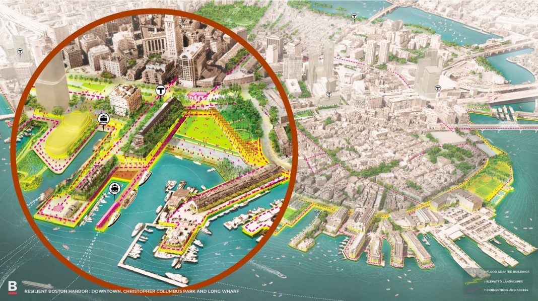
The Guidelines discusses the options for a resilient Boston Harbor by listing the various strategies that are currently being adapted through the CRB’s neighborhood plans. The options involve waterfront parks, vegetated berms, temporary flood barriers, a Harborwalk barrier, and raised roadways.


New designs for the Christopher Columbus Park, Langone/Puopolo Park, and Sargent’s Wharf are intended to create gateways to the Harbor and connect to the Greenway to protect the neighborhood from flooding. The New England Aquarium, one of the lowest lying areas, is exposed to the highest probability of flooding and is one source of the most significant flood risks for Downtown (alongside the Charles River Dam).

Although the Design Guidelines are currently only suggestions, the ongoing Zoning Overlay District (which is intended to work alongside the Guidelines) would allow the City to better influence and streamline resilient actions by eliminating regulatory barriers. The City is also working to update State Building Code and state environmental regulations as a way to provide another layer of resilience. To find out if your property lies within the coastal flooding risk use the BPDA Zoning Viewer and turn on the Sea Level Rise-Base Flood Elevation layer.


