
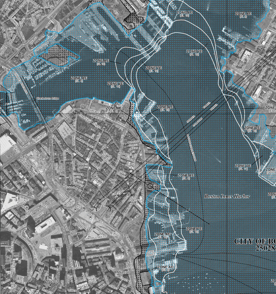
New preliminary flood zone maps have been published by FEMA and the flood line for the Boston’s North End / Waterfront goes much further inland than the previous risk assessment. If the maps released on November 15, 2013 go into effect as planned, property owners within the 1% chance flood line (i.e., the 100-year flood) will be required to purchase expensive flood insurance.
Many residents and businesses without a water view will also be subject to the new flood insurance requirement for the first time. In the North End, many of the wharves have that have partially been within the flood zone are now 100% included such as Commercial, Mercantile, Union, Lewis Wharves. Specifically, much of Commercial St., Atlantic Ave., North St., Fulton St. are within the new flood zone. The area around Medford Street is now included as far inland as N. Washington, Endicott and Thacher Streets. The flood zone also encroaches well into downtown Boston to Broad Street, Faneuil Hall and as far inland as City Hall Plaza. The newly developed Bulfinch Triangle in the West End is included within the flood zone for the first time.
This is the first update of the FEMA flood maps in over 20 years. Rising sea levels in Boston Harbor resulted in a much broader impact from potential storm surges, according to FEMA. The City of Boston is estimating that more than 10,000 additional properties could require flood insurance as a result of the new maps. Flood Hazard Mapping is an important part of the National Flood Insurance Program, as it is the basis of the NFIP regulations and flood insurance requirements. According to a news release, the earliest the City will adopt a final flood hazard map is December 2014.
“As a city, we’re committed to accurately identifying the risks from coastal storm flooding and finding ways to support those home and business owners who will be impacted by the remapping of the flood zones,” Mayor Menino said. “In the coming months, we’ll identify the effects of these new maps on insurance premiums and will continue to work with our State and Federal partners on solutions to help Boston residents and business owners mitigate increases in their flood insurance costs.”
Public meetings on the new maps are expected to be scheduled by FEMA. The City will also host neighborhood forums to help residents and businesses understand the new maps. A website has been established to collect resources regarding Flood Hazard Areas in Boston.
For comparison with the November 2013 map, the old flood map for the North End is shown below:


Hi neighbors – working with FEMA, insurance co, and mortgage companies to determine flood insurance is exactly what my business does. I work with property owners/ building management companies on risk assessment for flood insurance. The FEMA maps are a guideline, the true determination for flood insurance is the elevation of your property above sea level. In the coming weeks you will likely receive a notice from your mortgage company that you need flood insurance. Please note that individual condo owners can not buy flood insurance, it must be purchased by the condo association to cover the entire property. In the next few days I will reach out to neighborhood groups to get on upcoming agendas to provide an overview and answer questions. In the meantime, if you have questions feel free to email me: gcollins@bostonsurveyinc.com