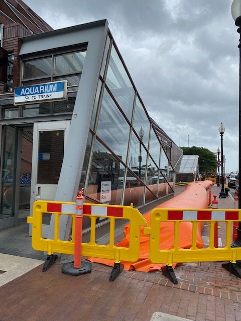
Adam Castiglioni shares these photos of flooding at Long Wharf during Monday’s “king tide.” King tides occur when the Earth, sun, and moon are as close to each other as possible in their relative orbits, combining to produce the greatest tidal effects of the year. It is above the highest water level reached at high Read More…
Tag: Rising Tides
Survey: Climate Change and Community Planning
Boston residents: Share your opinion about climate change and community planning. Click on the link to take our short survey by UMass Amherst researchers. Take the survey to earn an entry into our prize draw for a 50$ gift card.
Neighborhood Photo: Protecting the Aquarium MBTA Station
by Joanne Hayes Rines Employees from the MBTA surrounded the Aquarium T station with flood prevention tube and 5 T cars were parked on the street. Other materials were on hand if the entrance was in danger of flooding. “Neighborhood Photo” is a regular feature on NorthEndWaterfront.com. Send in your photos via email to info@northendwaterfront.com. Read More…
Boston’s Climate Flood Resiliency Options: 5′ High Bike/Roadways or Harborwalk Seawalls
Boston’s Climate Ready Downtown and the North End Project team recently gave an update on their plans to protect the neighborhood from flooding due to rising sea levels. Mayor Walsh has also started talking in more detail about potential seawalls as the study comes to an end in the Fall of 2019. Thanks to Michael Read More…
Boston Harbor Now’s “Waterfront Wednesdays” Episode 6: The F Word
Boston Harbor Now’s Director of Policy Jill Valdes Horwood and Director of Planning Alice Brown host a bi-weekly video blog covering topics related to the harbor. Watch their most recent episode about filled tidelands below. In this six minute vlog, Horwood and Brown talk about filled tidelands which are protected by Chapter 91, the public waterfront act. When original Read More…
Boston’s Environment Commissioner Talks Climate Resiliency for North End / Downtown [Video]
Chris Cook, chief of environment, energy and open spaces, for the City of Boston spoke to residents regarding the 2019 resiliency study for the North End and Downtown waterfront. With flooding now a regular occurrence on the waterfront, the Climate Ready Boston initiative aims to prepare Boston for the long-term impacts of climate change and rising Read More…
Elevating Sargent’s Wharf, Columbus, Langone Parks and Long Wharf in “Resilient Boston Harbor” Plan
Mayor Marty Walsh announced a broad plan to shore up several waterfront parcels from flooding, including in the North End and Downtown, as part his “Resilient Boston Harbor” vision. The City Hall strategy is a step forward in protecting the city from rising sea levels, especially during major storms and flooding events. In the North Read More…
Saturday’s High Tide – Flooding Continues [Photos]
The third and final high tide of Nor’Easter Riley hit Boston Saturday afternoon around 12:05pm, bringing strong wind gusts and additional flooding to the North End Waterfront. See photos below. More photos from Langone Park, the HarborWalk and under the North Washington Bridge: “Neighborhood Photo” is a regular feature on NorthEndWaterfront.com. Submit your interesting photos using Read More…
Storm Surge From Nor’Easter Riley Floods Boston’s Waterfront at High Tide [Photos]
High tide hit around 11:15 a.m. Friday morning with a near record storm surge from Nor’Eater Rlley causing dramatic flooding on Boston’s waterfront. It was the second massive storm in just as many months after the January 4th snowstorm. Shown here are photos from the flooding impact along the North End waterfront toward Long Wharf and Atlantic Read More…
Flooding & Climate Change Readiness – Seeking Data and Information
The Bomb Cyclone Storm of Jan. 4 left damage in its wet wake all along the local coast. You are invited to help others understand just where and how the North End experienced this storm. Our ability to educate ourselves more thoroughly about storm effects strengthens our sense of climate change readiness in the future. Read More…
City Responds to Development Planning Task Force For North End Waterfront Parcels
In an effort to avoid another war after the Lewis Wharf Hotel debacle, nine North End / Waterfront condominium boards reached out to city officials in a joint letter (pdf) to address the remaining open development parcels in the neighborhood. Specifically, the letter identified areas of development concern at Commercial Wharf, Lewis Wharf, Sargent’s Wharf, and vacant lots Read More…
What Happened? Sorting Through the January 2018 “Bomb Cyclone” Flood Data and Outlook
So, what happened to cause so much flooding during last week’s winter Nor’easter snow storm? Unlike the near miss of Hurricane Sandy where Boston dodged a (big) bullet, the so called “bomb cyclone” of January 2018 brought a storm surge that hit just at the worst time, an astronomical high tide. With already over 12 Read More…