The Climate Ready Boston team discussed the release of their long-awaited findings on the Downtown, North End and Dorchester neighborhoods at an event held on Thursday. Team members presented a project overview before shifting to a panel discussion and Q&A session.
Building on the Resilient Boston Harbor plan as well as the Imagine Boston 2003 initiative, the reports—Coastal Resilience Solutions for Downtown Boston and North End and Coastal Resilience Solutions for Dorchester—cover the City’s plan to address the impacts of sea level rise and coastal flooding due to climate change.
These reports focus on creating an equitable, sustainable path forward, and outline transformative plans to protect our homes, neighborhoods, and businesses from sea-level rise and flooding. We will continue to protect, connect, and enhance the City and Bostonian’s quality of life for years to come. —Mayor Walsh
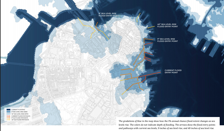
The report first discusses historical context, the team’s evaluation criteria, and future flood risk time frames. The maps below show the near-term, mid-term, and long-term risk of flooding due to sea level rise and coastal storm intensification for the North End and Waterfront neighborhoods.


Four district-wide strategies have been proposed:
- Spines—elevating existing linear elements such as roadways and bike paths.
- Open spaces—elevating existing and new public areas on or along the waterfront.
- HarborWalk enhancements—elevating the HarborWalk and integrating it with current bulkhead lines
- Offshore elements—filled land allowing for space required to raise elevations, or breakwaters and ecological systems at the water’s edge which reduce wave action and provide environmental benefits.

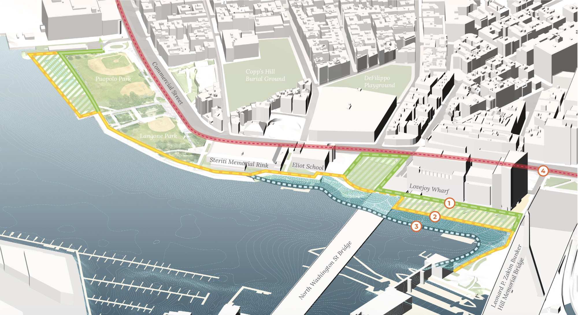
Specifically for the North End and Waterfront, four coastal resiliency strategies are presented, which are similar to the district-wide proposals:
Option 1: This two-part flood protection system includes a slightly elevated waterfront condition and a higher inland line of defense which reaches the 40 inch modular design flood elevation (DFE). This approach provides continued access to the water and may assist in access on and off the water where needed. The exact elevation of the new waterfront edge can be determined based on access, anticipated design life of the intervention, costs, and the tolerance of flooding risks to assets remaining below the 40 inch DFE.
Option 2: The flood protection system is completed entirely at the water’s edge, adapting the existing bulkhead wall to the required design flood elevation across the waterfront.
Option 3: Areas where outboard actions such as living shoreline or filled land may be required due to lack of space at the existing edge or advantageous for ecological or social reasons are indicated.
Option 4: Where a waterfront solution is not viable or able to be completed within the required timeline for district-wide protection, the alignment could be completed within the roadway through raising either the road itself or the bike path through the segment in which the waterfront option is not implemented.
The numbers in the diagrams below correspond to these options.


Discussion and Feedback:
Following a project overview, a panel discussion moderated by Climate Ready Boston’s Peyton Siller Jones drew on perspectives offered by Siller Jones’s project coordinator peer Zoe Davis; Chris Cook, Chief of Environment, Energy and Open Space; Liza Meyer, Chief Landscape Architect from City of Boston Parks; and BPDA (Boston Planning and Development Agency) Deputy Director of Planning Rich McGuinness.
Questions from the audience focused mainly on the use of data and feasibility. One resident asked how often the project team consults emerging data on sea level rise. Cook replied that official re-assessments occur every five years and added that the team is constantly adapting to the need for the integration of new information.
Downtown, North End, and Wharf District Planning
Over 400 residents from Downtown Boston, North End, and Wharf District neighborhoods participated in the Climate Ready Boston design process by joining meetings, attending community events, open houses, focus groups, and answering online surveys. As a result, several key elements of importance were revealed along the way.
Business owners have expressed concern regarding flood impacts on ground floor restaurants and retail, water-based transportation, rental properties, and damage to the historical and cultural assets such as the New England Aquarium, Custom House and Long Wharf, in addition to new amenities such as the Rose Kennedy Greenway.
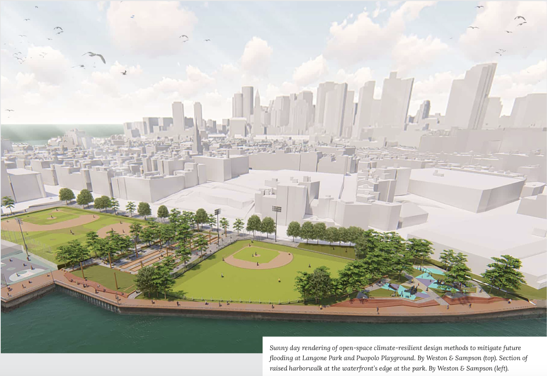
Identified as cornerstones of protection, Langone Park and Puopolo Playground will be the first project site to integrate standards established by the City’s Climate Resilient Design Standards and Guidelines for Protection of Public Rights-of-Way. The $15.3 million project will expand recreational opportunities, raise the level of the athletic fields out of the flood zone, elevate the harborwalk by four feet, and make the sea wall more structurally sound. Completion of the project is set for late fall 2020.
Next Steps

As depicted in the timeline above, the Langone/Puopolo Park project will be the first in several series of actions taken over time.
Near-term actions include the stretch of Downtown from Harbor Towers through Central Wharf, Long Wharf and Christopher Columbus Park as well as Lovejoy Wharf in the West End-North End Sub District. Waterfront properties from Christopher Columbus Park north to Union Wharf are currently inundated in large storm events and will require self protection in the short-term with planning for district scale protections getting underway within the next five years.
The majority of coastal resilience solutions in Downtown and North End, including Long Wharf, Central Wharf, Harbor Towers, Christopher Columbus Park, Commercial Wharf, Lewis Wharf, Sargents Wharf, Union Wharf, and Atlantic Avenue should be in place by 2030.
The City of Boston and the BPDA plan on convening a Long Wharf Property Owner Stakeholder Group.
The redesign of Christopher Columbus Park is set to include elevation to protect against flooding while improving waterfront open space and connections to the Rose Kennedy Greenway.
Multiple properties, institutions like the NEAQ (New England Aquarium), and the MBTA have already begun performing risk and vulnerability assessments. Explorations into various flood barrier systems are ongoing alongside necessary building and utility retrofits.
Read and download the full Downtown Boston and North End report.