
Last week’s historical photo featured an old image of the waterfront in 1906 (left). Thanks to our readers, we were able to identify the original high resolution image shown above. Click the top image to take a closer look.
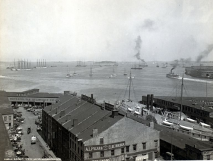
Although this location was initially identified as Union Wharf, the general consensus has lead us to believe it may be Central Wharf. Let us know your thoughts in the comments section below!
Tune in on Thursday’s to view our featured neighborhood photo from back in the day! Submit your historical photos by tagging @northend.waterfront on Instagram. Please include a caption or story telling about your photo.


Wonderfully sharp close up of this important historical photograph. Thank you for this intriguing view.
The island in the middle of Boston Harbor, in the upper far right corner of the photo, is Governor’s Island on which was Fort Winthrop. My mother and her siblings and friends, all East Boston natives, would motor out to Governor’s Island in my Uncle Bill’s 30′ motor launch to camp, fish, swim and recreate. There were 14 of them, so the boat was a good fit . Now Governor’s Island is also just a memory. The Island became the part of Logan Airport runways along with Wood Island Park (designed by the famous landscape architect, Frederick Law Olmstead). I spent many happy days
My parents, uncles, and aunts , like the Island and the Park, are gone now, and we adult children keep their stories and memories alive to share with the newer generations.
Who ever took the time to find that high res. photo thank you! seeing the hoarse dawn pickups of the day is much appreciated!