 After a year of study, city officials have put together their final plan to decrease the frustrations of traffic congestion in the North Station area, while also making neighborhood experiences safer and more enjoyable. The action plan recommends changes that will encourage people to use mobility options other than driving and increase incentives for biking and walking.
On Wednesday, the Boston Planning & Development Agency (BPDA) and the Boston Transportation Department (BTD), in conjunction with other city departments, have released the North Station Area Mobility Action Plan (NSAMAP) Final Report.
For over a year, the City has been working with neighborhood and community members to develop this transportation plan for the North Station Area, which includes parts of the West End, North End, and Bullfinch Triangle. The plan focuses on improving safety, making the neighborhood more understandable, increasing mobility options, and decreasing congestion.
The plan does not address development, but is inherently a response to the dozens of large-scale tower projects in the Bulfinch Triangle and West End neighborhood. While city officials ran the process, the study itself was paid for by area developers.
After analyzing feedback from community meetings and online polls, the NSAMAP project team started with 188 distinct ideas. The City used this creation process to determine the final action items: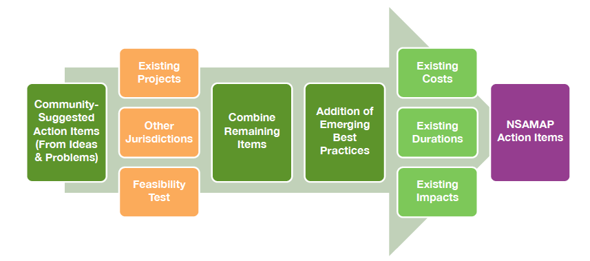 Around 20% of the suggested items were related to projects already being addressed, such as pedestrian bridges, bike parking, and MBTA improvements, among others. Some additional suggestions were outside the project scope or deemed infeasible. The remaining ideas were consolidated into 41 possible action items to be considered. A public meeting was held, as well as an online survey created, for community members to vote on these items. The results led to 18 final NSAMAP items.
Short-term action items (1-5 years) are displayed here: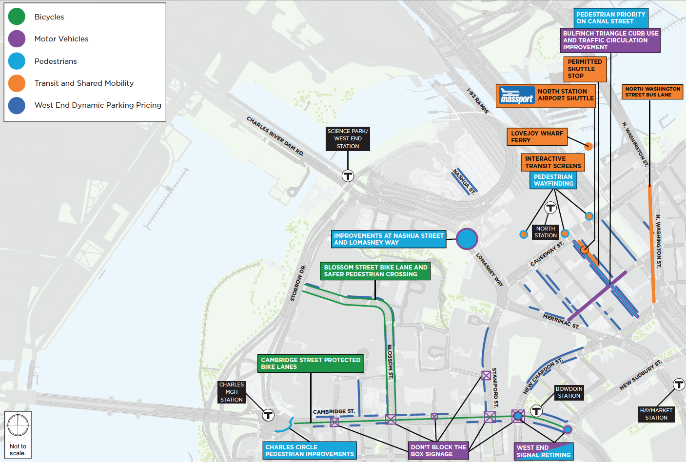 The top three most popular community suggestions all made the short-term action list:
- Cambridge Street protected bike lanes.
- Canal Street pedestrianization with commercial delivery.
- Lomasney Way / Nashua Street / Martha Way safety improvements for pedestrians and cyclists.
Other short-term action items that made the final plan are:
- Charles Circle pedestrian improvements at the Charles / MGH MBTA station.
- Bullfinch Triangle access and curb use improvements. This will include changing the direction of certain one-way streets and adding new handicap and metered parking.
- North Station – Airport shuttle bus.
- Encourage local employers and residential buildings to report progress annually on transportation demand management goals.
- Adaptive Signal Technology, which can react to traffic in real time to help manage rush hour congestion.
- North Washington Street bus lane.
- Performance-based parking meter pricing to increase availability of on-street parking in high-demand areas.
- Blossom Street bike lane and safer pedestrian crossings.
- Cambridge Street signal retiming at New Chardon Street and Sudbury Street.
- Permitted shuttle stop network with the goal of decreasing shuttles taking up curb space by encouraging shuttle consolidation by area.
- Pedestrian wayfinding and transit / ridesharing information screens.
- “Don’t Block the Box” signage on Cambridge Street.
Long-term action items (6 years or more) are displayed here: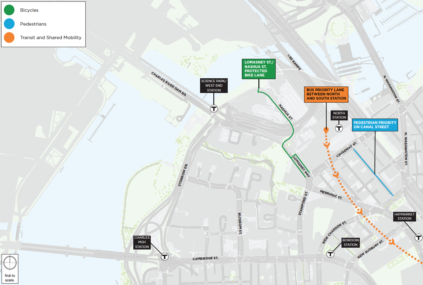 These projects include:
- Lomasney Way / Nashua Street protected bike lane (further improvements that will build upon the short-term item of new traffic signal and intersection improvements in this area).
- Bus priority lane between South Station, the Seaport, and North Station.
- Shared street construction on Canal Street that will allow for better flow of pedestrians.
This is just a brief overview of the final North Station Area Mobility Action Plan. Read the report in its entirety here.


I don’t think this deals with congestion as narrowing streets to provide bike lanes and shutting down Canal Street to traffic entirely isn’t helping traffic. The statement should just be…”We want to make the driving experience into North Station so miserable that people will seek alternatives to using their personal automobile.” Just call it like it is.
I don’t need a study and data to tell me the effects of bike lanes.
Anywhere a bike lane is installed traffic and congestion is quick to follow. I’ve lived in this area for 30 years. North station and commercial st never had this much traffic until they took away car lanes.
Nobody uses the protected bike lanes. very few people are riding a bike when it is below 30 degrees 4 months out of the year.
I think it got worse after they removed the on ramp to 93. Put a lot more cars into a congested area with no poossibility of a vent- off.
Also there is a real mess wth commuter trains putting a huge mess of pedestrians onto the street. The need for all those lights cause traffic to congest. Cabs with no where to pull over make the problem worse.
Simply putting a bike lane there will mean that is where the cabs will be. I ride a bicycle and I will do whatever it takes to avoid going throuh there. They can paint a stripe there, but it won’t make the situation more safe and less chaotic.
A HUGE issue currently is that three one-way streets: the first block of Canal (one way) and both ends of Valenti (one way) pour into the second half of Canal and it ends up being in a constant state of snarl with double parking and deliveries making things exponentially worse. I don’t see anything that would address what, to me, seems like basic poor flow?