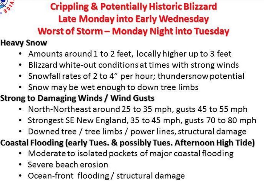
From the US National Weather Service – Boston: A crippling and potentially historic blizzard with more than 2 feet of snow and damaging winds will begin late Monday into Tuesday. Accumulating snows arrives Monday afternoon & impacts the late day commute. Then heavy snow arrives later Monday night into Tuesday morning with historic snowfall possible before the storm pulls away late Tuesday night or early Wednesday. In addition, Hurricane Force Wind gusts are likely across Cape Cod & the Islands late tonight into Tuesday morning.
Related Articles
Neighborhood Photo: Sun After Storm at Lewis Wharf
Jon Campanelli shares this photo of the sun poking through the trees in Lewis Wharf, following a snow storm in January. “Neighborhood Photo” is a regular feature on NorthEndWaterfront.com. Email your best photos toinfo@northendwaterfront.com. Please include a sentence (or more) telling us about your photo. See past neighborhood photo posts.
Another Close Call as Blizzard Juno’s Storm Surge Peaks at Low Tide
If Blizzard Juno’s storm surge of 4.74 feet hit during high tide, it would have been a “100-year” flood event for Boston’s waterfront, reports Julie Wormser of The Boston Harbor Association. We were again very lucky as the surge hit during low-tide just after 11 a.m. on Tuesday. (See NOAA’s tide and current data.) Despite the miss, the morning Read More…
Neighborhood Photo: Maya’s Dragon Struggles to Survive
“Maya’s Dragon,” labeled as such with a sign, is shrinking in the higher temperatures Monday. It was captured here on Sunday by Old North’s Rev. Steve Ayres at Hull and Snow Hill Streets.


